2011-08-27 2:14 EDT
[Clarifications: 2011-08-28 6:30 EDT]
As I write this hurricane Irene is a few hours away from hitting New York City, where I am writing. Given that you are probably, as I am, stuck inside, you might have a few moments to read a bulk e-mail containing some thoughts from a (former) scientist.
As you would expect, there is a great deal of coverage of the impending weather events. Because reporters have has had it hammered into them that no single weather event is a demonstration of climate change, not very much of the coverage makes any connection with global warming.
That is a shame, because while it is true that there were hurricanes like this before hitting New York before there was substantial human-induced climate change, that does not mean that there is no connection to be drawn. If you would bear with me for a moment, you can see why there is actually quite a bit to learn from this event.
A hurricane is a natural example of what scientists call a "heat engine". The invention of heat engines in the 19th century was the defining change of the industrial revolution. A heat engine is a device for taking heat from a hot body, moving some of the heat to a colder body, and making mechanical motion in the process. For example, the burned gasoline inside the cylinder of your car is an example of hot body, and when your car drives it converts some of the energy into motion of the car, while some goes out the tailpipe and radiator as heat.
A hurricane does the same thing. It takes heat from the warm ocean, moves some of it into the cooler air of the upper atmosphere, and makes motion (wind) in the process. There is a reasonably good explanation of it in some undergraduate course notes I found here. As you can see, the key ingredient is warm water - over 27C (81F). Since human greenhouse gas emissions are warming the planet, it is reasonable to suppose that there will be an effect on hurricanes.
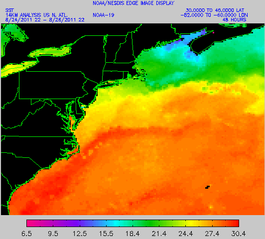
Right now, the temperature of the water off the North Atlantic coast is unusually warm. The first image below is from the National Oceanographic and Atmospheric Administration (NOAA) web site here
As you can see, there is water of about 27C all the way up the coast of New Jersey. [Clarification: the warmest water is actually further away from the shore than the storm actually took. However the water near the coast is also warmer than usual, as discussed below.] That means a hurricane can keep working pretty far north. Now that doesn't tell us anything by itself, as the relevant question is whether that is usual. The next image is what is called Sea Surface Temperature Anomaly, which measures how the temperature compares to the average. The link is here.
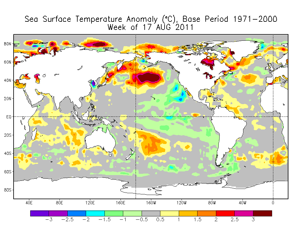
As you can see, off the northeast coast, there is a patch of unusually warm water. (You can also see that the map contains many more patches of reds and yellows than blues and greens, especially in the arctic areas, reflecting overall warming.) The presence of this patch of warm water means that the hurricane will retain its strength further north than it otherwise might have. This means that when it hits New York, Irene will be stronger than she would have been had the water the northeast been cooler. (With appropriate caveats about the wind shear being the same.)
This is an example of what the climate scientists mean when they say that while we can't attribute this particular event to global warming (there are always patches of warm water here and there), we are loading the dice in favor of these sorts of events. Here is how James Hansen of NASA put it: "The standard scientist answer is 'you cannot blame a specific weather/climate event on global warming.' That answer, to the public, translates as 'no'. However, if the question were posed as 'would these events have occurred if atmospheric carbon dioxide had remained at its pre-idustrial level of 280 ppm?', an appropriate answer in that case is 'almost certainly not'. That answer, to the public, translates as 'yes', i.e., humans probably bear a responsibility for the extreme event." [Clarification: the unusual event being referred to here is the warm water, not the hurricane itself.]
One further thought, if you will bear with me.
In 2007 the Intergovernmental Panel on Climate Change (IPCC) issued a report that seemed to show that if we continue emitting greenhouse gasses under a "business as usual" scenario, sea level would rise 1-2 feet. During the subsequent four years, it has become clear that this was misleadingly conservative. Now, a more viable view would be 3-6 feet of sea level rise by 2100. (This of course keeps going into the 22nd century.)
Here is a chart that shows what happens to New York City under a storm surge from Category 1, 2, and 3 hurricanes.
By way of comparison, a category 1 hurricane comes with 4-5 feet of storm surge, category 2 with 6-8 ft and category 3 with 9-12 ft. (See http://en.wikipedia.org/wiki/Saffir%E2%80%93Simpson_Hurricane_Scale).)
So, in the future, the water will be significantly higher, and when hurricanes do hit they are likely to be stronger.
Gives a new meaning to the phrase "Brighton Beach Memories".